UConn, Univ. of Alaska-Fairbanks, and Univ. of Virginia secure $1.3M from the National Science Foundation (NSF) to Study Arctic Tundra Landscape

Dr. Chandi Witharana and his collaborators from University of Alaska-Fairbanks and University of Virginia recently received a $1.3M research grant from the NSF Arctic System Science program to deepen our understanding on the complex and interlinked processes responsible for the evolution of the pan-Arctic ice-wedge polygon tundra landscape. Tundra wetlands have been called the “Serengeti of the North,” because they are home to abundant wildlife populations that migrate to the Arctic from all regions of the world. These animals, which includes three threatened and one endangered species, rely on Arctic wetlands and their uncertain future. This three-year project will help identify key mechanisms affecting the resilience of ice wedges to climate change, and the effects of ice-wedge degradation on watershed hydrology, while also providing the first pan-Arctic map of ice-wedge polygons that is key for future efforts in scaling up to the pan-Arctic domain
Dr. Witharana leads the methodological development of novel remote sensing data processing workflows to enable high-resolution imagery based, pan-Arctic domain, automated mapping of tundra landscapes. His work will put into practice deep learning, high performance computing, and the sheer volumes of sub-meter satellite imagery from the Polar
Geospatial Center at the University of Minnesota.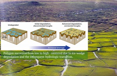
The warming Arctic is reshaping the tundra landscape as thousands-year-old ground-ice thaws, resulting in differential ground settlement that alters the distribution of water and snow in a region with desert-like precipitation. A multitude of field measurements across the Arctic have documented long-term and gradual warming of permafrost and, more recently, the observations have also included rapid ice-wedge degradation in response to a single and unusually warm summer. This project will combine field measurements from nine Canadian, Russian, and Alaskan field sites, numerical modeling, and very high spatial resolution optical imagery that has recently become available for the entire Arctic tundra domain.